
Application of Remote Sensing and GIS for Earthquake
February 21, 2023 2023-02-21 2:18Application of Remote Sensing and GIS for Earthquake
Mapping of earthquakes using remote sensing and GIS (Geographic Information Systems) involves the integration of data from different sources to create a spatially referenced representation of earthquake activity.
Remote sensing technology uses instruments such as satellites, airborne sensors, and ground-based sensors to collect data about the Earth’s surface and atmosphere. These data include measurements of land cover, elevation, temperature, and other physical and environmental variables that are useful in studying earthquake activity.
GIS software, on the other hand, allows the user to store, analyze, and visualize geographic data, including satellite imagery and other remote sensing data. GIS software also provides tools for spatial analysis and modeling, which are useful in understanding the distribution and patterns of earthquake activity.
-
Case Study
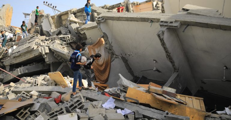
A powerful earthquake with a magnitude of 9.0, occurred on March 11, 2011, in Tohoku, Japan. The earthquake was caused by the subduction of the Pacific Plate beneath the North American Plate, and it was the most powerful earthquake to ever hit Japan.
The earthquake triggered a massive tsunami that devastated the coastline, causing widespread damage and loss of life. The tsunami reached heights of up to 40 meters (130 feet) and traveled inland as far as 10 kilometers (6.2 miles) in some areas. The combined effects of the earthquake and tsunami resulted in more than 15,000 deaths, and over 2,500 people were reported missing.
The earthquake also caused significant damage to infrastructure, including roads, bridges, and buildings. The Fukushima Daiichi nuclear power plant was also damaged, leading to a nuclear disaster that was declared a Level 7 event on the International Nuclear Event Scale, the same level as the Chernobyl disaster. Remote sensing and GIS played a critical role in mapping the impact of the earthquake and tsunami and aiding in the response and recovery efforts. Satellite imagery was used to assess the extent of the damage caused by the earthquake and tsunami, and the data was processed and integrated with GIS data to create maps that helped to identify areas that required the most attention in terms of relief and recovery efforts.
The following steps are involved in mapping earthquakes using remote sensing and GIS:
Collecting Remote Sensing Data: Remote sensing data can be collected from various sources, including satellite imagery, aerial photography, and ground-based sensors. These data provide information about the Earth’s surface and can be used to identify and map areas that are prone to earthquakes.
Pre-processing Remote Sensing Data: Before using the remote sensing data for earthquake mapping, they need to be pre-processed to remove errors, enhance the quality, and extract the required features. This can be done using image processing techniques like filtering, enhancement, and image fusion.
Integration of Remote Sensing and GIS data: Once the remote sensing data has been processed, it is integrated with GIS data, including land-use maps, topographic maps, and other spatial data to create a comprehensive view of the study area.
Analysis and Interpretation: The integrated data is analyzed and interpreted to identify patterns of earthquake activity, including their frequency, magnitude, and location. This can be done using statistical and spatial analysis tools available in the GIS software.
Creating Maps: Finally, the results are presented in the form of maps, which display the distribution and patterns of earthquake activity. These maps can be used to identify high-risk areas, assess the potential impact of earthquakes, and develop mitigation strategies.
In conclusion, mapping earthquakes using remote sensing and GIS is a powerful tool for understanding and managing earthquake risk. It provides valuable information that can be used to improve emergency response, planning, and policy decisions related to earthquake mitigation and disaster management.
Abbreviation
GIS: A geographic information system (GIS) is a computer system that generates, maintains, analyses, and maps various types of data. GIS integrates data to a map by combining location data (where objects are) with other forms of descriptive data (what things are like there).
Remote sensing: Remote sensing is the practice of detecting and monitoring an area’s physical features from a distance by measuring it’s reflected and emitted radiation (typically from satellite or aircraft).

Comments (2)
Neamul Ahsan Khan
Remote sensing and GIS technologies are essential for regional earthquake-triggered landslide susceptibility and hazard assessments. Remote sensing is important for preparing completed and detailed landslide inventory maps and producing environmental thematic maps.
Arijit Mondal
Remote sensing and GIS field interest