Most popular
Free
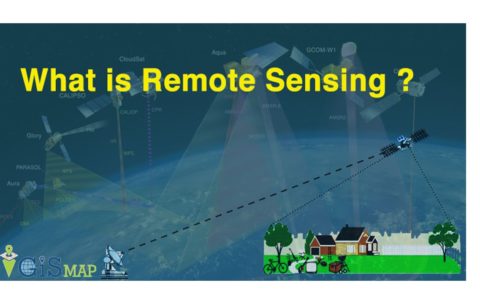
Principle of remote sensing
What you'll learn
At the end of the course students will be able to:
• Identify the principles of how remote sensing images are acquired
• Understand how Electromagnetic radiation interacts with the Earth & Atmosphere
• Interoperate and extract usable information from remotely sensed images using remote sensing image processing computer systems
• Explore the potential applications of remote sensing images in solving real-world geographic problems.
• Examine the advantages of using remote sensing image data in solving real-world geographic problems
• Identify the characteristics of different types of remote sensing images and their respective application
Trending
Free
Principle of remote sensing
What you'll learn
At the end of the course students will be able to:
• Identify the principles of how remote sensing images are acquired
• Understand how Electromagnetic radiation interacts with the Earth & Atmosphere
• Interoperate and extract usable information from remotely sensed images using remote sensing image processing computer systems
• Explore the potential applications of remote sensing images in solving real-world geographic problems.
• Examine the advantages of using remote sensing image data in solving real-world geographic problems
• Identify the characteristics of different types of remote sensing images and their respective application
Featured Courses
Featured
Free
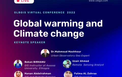
Olbgis Virtual Conference 2022 : Global Warming and Climate Change
Olbgis Conference 2022 is the leading conference for GIS specialists …

All NASA Earth Observatory Courses
Featured
Free
Olbgis Virtual Conference 2022 : Global Warming and Climate Change
Olbgis Conference 2022 is the leading conference for GIS specialists …
Free
Principle of remote sensing
This course introduces the theory and techniques of remote sensing …
What you'll learn
At the end of the course students will be able to:
• Identify the principles of how remote sensing images are acquired
• Understand how Electromagnetic radiation interacts with the Earth & Atmosphere
• Interoperate and extract usable information from remotely sensed images using remote sensing image processing computer systems
• Explore the potential applications of remote sensing images in solving real-world geographic problems.
• Examine the advantages of using remote sensing image data in solving real-world geographic problems
• Identify the characteristics of different types of remote sensing images and their respective application
