Most popular

Featured
Free
Olbgis Conference 2020
What you'll learn
You will understand how GIS (Geographical Information System) is changing the world through its usage and applications.
During the conference, we will present you with 02 GIS applications to help you open your mind to how GIS is affecting your daily life.
The first topic will be GIS in Utilities: Upstream & Downstream Network; Operations Management in GIS. Incident Management. Reporting & Business Intelligence.
The second topic will be: Application of GIS and remote sensing in agriculture (case of Egypt), you will better understand crop productivity and monitoring using the Crop Assimilation Model tool in GRASS GIS.
Featured
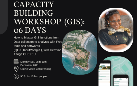
Capacity Building Workshop Geographical Information Systems (GIS): 06 DAYS
What you'll learn
Understand GIS: their components, processes, uses and types of data;
Be autonomous on mobile GIS geolocation tools and data collection and supervision techniques;
Model and set up a GEODATABASE
Carry out thematic analyzes by categorization to facilitate decision-making;
Produce maps by theme
Design and produce thematic and interactive maps on ArcGis Online

Featured
Drone Mapping : Turn your drone in productivity tool (advanced level)
What you'll learn
At the End of this section you will be able to:
- Analyse Map soils,
- Analyse vegetations,
- Analyse surface hydrology
- And Analyse ground-water using drone technology.
Featured
Advanced courses of Webgis Programming: from the Beginner to Expert
What you'll learn
This course will provide you with the knowledge you need to :
create a Leaflet web map
add map controls
choose from a variety of background maps
add your own GIS to it
style your data
find specific data
analyze spatial relationships
At the end of the course you will be able to create web interfaces to view, search, and analyze your GIS data and make them accessible to anyone with a web interface for free!
what you will learn in this course?
to find and zoom to your position on a map
to use leaflet controls for user interface, geocoding, editing, and loading data
to use background maps
to create vector data and style it in your map
to export your GIS data to GeoJSON format and load it into the map
to filter a subset of your data
to search for specific data elements and view their attributes
to analyze spatial relationships
more and more
Trending
Featured
Free
Olbgis Conference 2020
What you'll learn
You will understand how GIS (Geographical Information System) is changing the world through its usage and applications.
During the conference, we will present you with 02 GIS applications to help you open your mind to how GIS is affecting your daily life.
The first topic will be GIS in Utilities: Upstream & Downstream Network; Operations Management in GIS. Incident Management. Reporting & Business Intelligence.
The second topic will be: Application of GIS and remote sensing in agriculture (case of Egypt), you will better understand crop productivity and monitoring using the Crop Assimilation Model tool in GRASS GIS.
Featured
Capacity Building Workshop Geographical Information Systems (GIS): 06 DAYS
What you'll learn
Understand GIS: their components, processes, uses and types of data;
Be autonomous on mobile GIS geolocation tools and data collection and supervision techniques;
Model and set up a GEODATABASE
Carry out thematic analyzes by categorization to facilitate decision-making;
Produce maps by theme
Design and produce thematic and interactive maps on ArcGis Online
Featured
Drone Mapping : Turn your drone in productivity tool (advanced level)
What you'll learn
At the End of this section you will be able to:
- Analyse Map soils,
- Analyse vegetations,
- Analyse surface hydrology
- And Analyse ground-water using drone technology.
Featured
Advanced courses of Webgis Programming: from the Beginner to Expert
What you'll learn
This course will provide you with the knowledge you need to :
create a Leaflet web map
add map controls
choose from a variety of background maps
add your own GIS to it
style your data
find specific data
analyze spatial relationships
At the end of the course you will be able to create web interfaces to view, search, and analyze your GIS data and make them accessible to anyone with a web interface for free!
what you will learn in this course?
to find and zoom to your position on a map
to use leaflet controls for user interface, geocoding, editing, and loading data
to use background maps
to create vector data and style it in your map
to export your GIS data to GeoJSON format and load it into the map
to filter a subset of your data
to search for specific data elements and view their attributes
to analyze spatial relationships
more and more
Featured Courses
Featured
Advanced courses of Webgis Programming: from the Beginner to Expert
L’objectif de ce cours est d’étudier l’utilisation du SIG dans …
Advanced courses of Webgis Programming: from the Beginner to Expert
What you'll learn
This course will provide you with the knowledge you need to :
create a Leaflet web map
add map controls
choose from a variety of background maps
add your own GIS to it
style your data
find specific data
analyze spatial relationships
At the end of the course you will be able to create web interfaces to view, search, and analyze your GIS data and make them accessible to anyone with a web interface for free!
what you will learn in this course?
to find and zoom to your position on a map
to use leaflet controls for user interface, geocoding, editing, and loading data
to use background maps
to create vector data and style it in your map
to export your GIS data to GeoJSON format and load it into the map
to filter a subset of your data
to search for specific data elements and view their attributes
to analyze spatial relationships
more and more
Featured
Capacity Building Workshop Geographical Information Systems (GIS): 06 DAYS
This training aims to allow participants to master the different …
Capacity Building Workshop Geographical Information Systems (GIS): 06 DAYS
What you'll learn
Understand GIS: their components, processes, uses and types of data;
Be autonomous on mobile GIS geolocation tools and data collection and supervision techniques;
Model and set up a GEODATABASE
Carry out thematic analyzes by categorization to facilitate decision-making;
Produce maps by theme
Design and produce thematic and interactive maps on ArcGis Online
Featured
Drone Mapping : Turn your drone in productivity tool (advanced level)
In the last year, the drone industry has exploded. This …
Drone Mapping : Turn your drone in productivity tool (advanced level)
What you'll learn
At the End of this section you will be able to:
- Analyse Map soils,
- Analyse vegetations,
- Analyse surface hydrology
- And Analyse ground-water using drone technology.
Featured
Free
Olbgis Conference 2020
Olbgis Conference 2020 is the leading conference for GIS specialists …
Olbgis Conference 2020
What you'll learn
You will understand how GIS (Geographical Information System) is changing the world through its usage and applications.
During the conference, we will present you with 02 GIS applications to help you open your mind to how GIS is affecting your daily life.
The first topic will be GIS in Utilities: Upstream & Downstream Network; Operations Management in GIS. Incident Management. Reporting & Business Intelligence.
The second topic will be: Application of GIS and remote sensing in agriculture (case of Egypt), you will better understand crop productivity and monitoring using the Crop Assimilation Model tool in GRASS GIS.


All Agriculture Courses
Featured
Advanced courses of Webgis Programming: from the Beginner to Expert
L’objectif de ce cours est d’étudier l’utilisation du SIG dans …
What you'll learn
This course will provide you with the knowledge you need to :
create a Leaflet web map
add map controls
choose from a variety of background maps
add your own GIS to it
style your data
find specific data
analyze spatial relationships
At the end of the course you will be able to create web interfaces to view, search, and analyze your GIS data and make them accessible to anyone with a web interface for free!
what you will learn in this course?
to find and zoom to your position on a map
to use leaflet controls for user interface, geocoding, editing, and loading data
to use background maps
to create vector data and style it in your map
to export your GIS data to GeoJSON format and load it into the map
to filter a subset of your data
to search for specific data elements and view their attributes
to analyze spatial relationships
more and more
Featured
Capacity Building Workshop Geographical Information Systems (GIS): 06 DAYS
This training aims to allow participants to master the different …
What you'll learn
Understand GIS: their components, processes, uses and types of data;
Be autonomous on mobile GIS geolocation tools and data collection and supervision techniques;
Model and set up a GEODATABASE
Carry out thematic analyzes by categorization to facilitate decision-making;
Produce maps by theme
Design and produce thematic and interactive maps on ArcGis Online
Featured
Drone Mapping : Turn your drone in productivity tool (advanced level)
In the last year, the drone industry has exploded. This …
What you'll learn
At the End of this section you will be able to:
- Analyse Map soils,
- Analyse vegetations,
- Analyse surface hydrology
- And Analyse ground-water using drone technology.
Featured
Free
Olbgis Conference 2020
Olbgis Conference 2020 is the leading conference for GIS specialists …
What you'll learn
You will understand how GIS (Geographical Information System) is changing the world through its usage and applications.
During the conference, we will present you with 02 GIS applications to help you open your mind to how GIS is affecting your daily life.
The first topic will be GIS in Utilities: Upstream & Downstream Network; Operations Management in GIS. Incident Management. Reporting & Business Intelligence.
The second topic will be: Application of GIS and remote sensing in agriculture (case of Egypt), you will better understand crop productivity and monitoring using the Crop Assimilation Model tool in GRASS GIS.
